Ethiopian News, Current Affairs and Opinion Forum
Zmeselo
Senior Member+
Posts: 36815
Joined: 30 Jul 2010, 20:43

India in Eritrea.

Post by Zmeselo » 17 Oct 2019, 18:47

India in Eritrea (@IndiaEritrea) Tweeted:

Ambassador called on H.E. Mr. Arefaine Berhe, Hon'ble Minister of Agriculture of Eritrea. Happy to know, that Eritrea is poised for a bumper harvest this year.


_______________________

(Courtesy: SAMSOM BERHANE @samsom_berhane)

The potential for Agriculture is huge, in Eritrea. The country has 2.1 million ha of arable land, suitable for crop & horticulture. Of it, 1.2 mill. ha is suitable for rain- fed & 0.6 mill. ha for irrigation. The ongoing endeavor, will modernize the sector & turn it net exporter.

Last edited by Zmeselo on 17 Oct 2019, 19:29, edited 1 time in total.

Zmeselo
Senior Member+
Posts: 36815
Joined: 30 Jul 2010, 20:43

Re: India in Eritrea.

Post by Zmeselo » 17 Oct 2019, 19:07


Amphora: Evidence of the long-distance trade across the wider circuit of the Red Sea

Written by Natnael Tekle

http://www.shabait.com/about-eritrea/hi ... e-red-sea-

About Eritrea - History & Culture


One of the earliest inventions by early humans was the ability to make Pottery, to use them as containers in their daily lives. The art of pottery making is believed to have startedz during the 7th millennium B.C. In prehistoric times, it is assumed that water was carried in woven baskets lined with river clay.

After the water was poured out of the container, the layer of clay dried. The loss of moisture, caused the shape to shrink and be separated from the sides of the basket. When the clay, now shaped like a pot, was removed and dried in the sun on hot sand, it retained the basket’s pattern. Early men and women then discovered, that they could harden the molded pottery in hot ashes and make sturdy containers to transport and store food. From these, would have been extended the pots formed by hand and decorated with crude tools. Due to its abundance and durability, pottery is one of the most common types of items found by archaeologists during excavations, and it has the potential of providing valuable information about the human past.

An amphora (Greek: amphoreus) is a jar with two vertical handles, used in antiquity for the storage and transportation of food stuffs; such as wine and olive oil. The name comes from the Greek amphiphoreus, which means ‘carried on both sides’. The Greeks had adopted the design, from the eastern Mediterranean. Used by all the great trading nations, from the Phoenicians to the Romans, the sturdy-walled amphora spread throughout the ancient world and they have become an important survivor in the archaeological record; providing clues as to dates of sites, trade relations, and everyday diet.

Archaeological findings revealed the existence of amphora almost in all the major ancient sites in Eritrea; such as the ancient port of Adulis, Qohaito and Metera. Those findings, provide us with answers about the ancient civilizations and developments in our region. The analysis and interpretation of ceramic remains allow archaeologist to accomplish varied ends, establish dates and chronologies, document interconnections between different areas and suggest the function and status of people and places. Patterns in the production, distribution and exchange of trading materials often help archaeologists to reconstruct wider circuits of long-distance trade among peoples of different civilizations in antiquity. The origin and distribution of materials, thus, becomes a reference to tackle these key aspects of the antiquity of the northern Horn of Africa.


Amphora assemblages represent one of the major evidence of the long-distance trade between the Red Sea coast with the Roman, Byzantine and other empires approximately around the 2nd millennium BCE and 1st millennium CE. Amphora assemblages were produced across much of the Roman Empire, from the Iberian Peninsula (Spain and Portugal) to France and from the Italian peninsula to the Roman Province of North Africa and Eastern Mediterranean. Amphora assemblages are given different classifications by different archaeologists, to represent their production centers across the world; as well as their chronologies. The archaeological record from the ancient port city of Adulis in Eritrea, shows evidence of Early Roman wine amphora (dating to the late 1st millennium BCE to early 1st millennium CE) as well as the so-called Ayla amphora from the Byzantine period (particularly from the 4th to 7th centuries CE).

The Ayla Amphora or Aqaba Amphora are long and conical “carrot shaped” amphoras, decorated with corrugations, that have been found in the widest range of finds in the Red Sea. These Amphoras have a conical or carrot shape with slight shoulders, [deleted] base and ribbed body. The neck is short with vertical and rounded rim in the upper part and in most cases there is an internal ledge below the rim for receiving the lid. The ovoid or elliptical in section handles, start from the neck and go to the shoulders. The surface of these amphoras is often covered with a light-colored slip. Subsequent findings, since the mid- 1990s, indicate, however, that the amphoras originate in Byzantine, or even early Islamic Aqaba (Jordan). One astonishing discovery made in 1995 at Black Assarca Island, Eritrea, “The Black Assarca shipwreck”, revealed large assemblages of a variety of artifacts of Near Eastern/ Mediterranean origin, including Ayla or Aqaba Amphoras. Based on the finds at these sites, the Black Assarca ceramics are thought to date from around the 5th or 6th century, with the wreck possibly dating from the early 7th century. The Ayla Amphoras are presumed to have been produced at the ancient port of Ayla (Aqaba), in present day Jordan. These Amphoras assemblages which are presumed to have Eastern Mediterranean origin were also found in Myos Hormos and Berenike in Egypt, Adulis, Assarca and Matara in Eritrea, Axum in Ethiopia as well as Zafar in Yemen. The Ayla Amphoras provide a glimpse of the long-distance trade across the wider circuit of the Red Sea, Eastern Mediterranean and the Indian Ocean during the Byzantine period.


These varieties of amphora assemblages have expanded our knowledge of the probable origin and distribution patterns of amphora across the Red Sea, the Indian Ocean and also throughout the world. The Early Roman wine amphoras found at the ancient port city of Adulis, belong mainly to the Dressel 2-4 typology; believed to have been imported from the Italian peninsula and the Roman province of Egypt (principally the ancient ports of Myos Hormos and Berenike). These amphora assemblages have been found at Adulis with other forms of ceramic assemblages from North Africa, including the African sigillata forms allowing us to understand the connections with the wider Red Sea world.

The Dressel 2-4 amphora were particular of the Red Sea Coast of East Africa, Southern Arabia and the Indian sub-continent to transport wine and have been found in these regions in large assemblages. Apart from the apparent connections with the Roman and Byzantine worlds, the Red Sea Coast of Eritrea had trading contacts with the Persian Gulf and the Indian sub-continent; as understood from pottery uncovered along the coast.

Amphoras can be considered a crucial commercial and political link between the Red Sea coast, in general, and Eritrea, in particular, with the Roman, Byzantine, Persian, Indian and other empires. Not only does it provide information on the trade relations between various societies but it also takes us further into the dietary habits of these societies.

Zmeselo
Senior Member+
Posts: 36815
Joined: 30 Jul 2010, 20:43

Re: India in Eritrea.

Post by Zmeselo » 17 Oct 2019, 19:13


______________________

@TheCBSO, sounding great ahead of tonight's exciting #TheThrillOfTheNew concert. #Birmingham


Preparations for Daniel Kidane's " Woke" performance, in Birmingham.


Strong Eritrean contingent at this evening's @TheCBSO concert at @THSHBirmingham 🇪🇷
Last edited by Zmeselo on 18 Oct 2019, 08:36, edited 2 times in total.

Zmeselo
Senior Member+
Posts: 36815
Joined: 30 Jul 2010, 20:43

Re: India in Eritrea.

Post by Zmeselo » 17 Oct 2019, 19:17


Zmeselo
Senior Member+
Posts: 36815
Joined: 30 Jul 2010, 20:43

Re: India in Eritrea.

Post by Zmeselo » 17 Oct 2019, 19:25

Hon. Aden Duale (@HonAdenDuale) Tweeted:

With Eritrean Ambassador to Kenya and Dean of African Diplomatic Corps H.E. Beyene Russom, who called on me in my office at Parliament Building, Nairobi. @NAssemblyKE


We discussed issues of common interest, encompassing strengthening the relationship of our two countries and supporting all efforts to bring peace and security in the Horn of Africa.


Appreciated the support by Eritrea as one of the countries that stood with Kenya in its bid for the United Nations Security Council non-permanent seat position, in 2020-2021.


Zmeselo
Senior Member+
Posts: 36815
Joined: 30 Jul 2010, 20:43

Re: India in Eritrea.

Post by Zmeselo » 17 Oct 2019, 19:38

Eritrea, has one of the northernmost populations of African elephants. The number of elephant population in the country, that was 15 according to the study conducted in 1996 has currently reached to 250, Eritrean Forestry and Wild Life Authority reported.


___________________


It is projected that about 100 tonnes of fish per year will be produced from the water reservoirs supported by #FReMP, as the 70 stocked dams in the country can produce approximately 350 tonnes of fish per year. #FoodSecurity
Last edited by Zmeselo on 18 Oct 2019, 08:39, edited 1 time in total.

Zmeselo
Senior Member+
Posts: 36815
Joined: 30 Jul 2010, 20:43

Re: India in Eritrea.

Post by Zmeselo » 18 Oct 2019, 08:27


Zmeselo
Senior Member+
Posts: 36815
Joined: 30 Jul 2010, 20:43

Re: India in Eritrea.

Post by Zmeselo » 18 Oct 2019, 08:40


Zmeselo
Senior Member+
Posts: 36815
Joined: 30 Jul 2010, 20:43

Re: India in Eritrea.

Post by Zmeselo » 18 Oct 2019, 08:44

Nation building is a challenging process requires persistence toward grand objective, stamina on trying times & pragmatism on dealing with reality. The past 28 years of development trajectories in the face of war, state of war & sanctions proved #Eritrea is destined to progress.

Eritrea living condition in 1991 (ref. WB & UN)
*unemployment over 70%
* 65% below the poverty line (75% Food aid)
*:Overcrowded & substandard housing
* Maternal mortality rate 998/100,000
* Under-5 mortality 35/1000,000
* High prevalence of communicable diseases
* Life expectancy 46 years

Eritrea progress in key areas since 1991

* Life expectancy from 46 to 67 years
* Adult literacy from 20% to 80% in 2014
* Student population from 200k to over 600k, university students from 1.2k to14k
* 1.1k new villages & 70% households accessed safe water
* 128k Residential lots distributed
* Maternal mortality dropped to 250/100k
* Child u-5 mortality droppted to 48/100k

(source, MDG Report 2016)

Zmeselo
Senior Member+
Posts: 36815
Joined: 30 Jul 2010, 20:43

Re: India in Eritrea.

Post by Zmeselo » 18 Oct 2019, 08:52

Amb. Sophia Tesfamariam (@stesfamariam) Tweeted:

Eritrea participated in round table discussion with Dr. Paul Oquist Kelley, Minister-Private Secretary 4 National Policies of the President @ Nicaragua Mission @UN

-Shared, Eritrea's Minimum Integrated Household Agricultural Package (MIHAP) #SDGs @GlobalGoalsUN


Zmeselo
Senior Member+
Posts: 36815
Joined: 30 Jul 2010, 20:43

Re: India in Eritrea.

Post by Zmeselo » 18 Oct 2019, 09:01

Tourist Sites of the Gash-Barka Region

Wednesday, 16 October 2019

Written by Shabait Administrator

http://www.shabait.com/categoryblog/294 ... rka-region


Gash-Barka, is the largest region in Eritrea by land mass. It has a population of more than 800,000 and borders Anseba region to the north, Sudan to the west and Ethiopia to the south. Gash-Baraka, which is well-suited for agricultural and commercial ventures, has also a potential to be a tourist attraction site with its rich cultural and historical resources and land-scape. It is home to almost all Eritrean ethnic groups.

Since the tourism resource of this region is so abundant, in this issue we present you with some of the sites that are worth visiting. These include Mount Aylet which has natural and historical beauty, Degiat Gurja Fortress which was used as a defense line and residential area in the 17th century, the ancient Marieta natural water reservoir located along the Gash River, Italian fortresses near Agordat, Mount Adal (where the Eritrean struggle for independence started) and the unique wild life of the region.

Mount Aylet

This is a place where the local people defeated a Dervish invading army that greatly outnumbered them. The mountain is home to a number of cottages, tombs and mosques and other materials that reflect the life of the people back in the 17th century.

Mount Aylet is located about 6 km to the north-west of the town of Haikota. According to legends, the local people used the mountain as a fortress to fight back invaders. During the Ethiopian colonial times the place known as Darglieta, which means the floor of the earth, was used to defend against the Haileslassie and Dergue military offensives.

A quarter of an hour walk from Darglieta there is a place known as Tingalieka, which means “a high floor”, about 6 times of the area of Derglieta. In Tingalieka there are different monuments, including more than 50 ancient graves. According to the people of Aylet, the graves have very well constructed stairs. Each grave belongs to one family. When a family member dies, he/she is buried in the family grave and then the grave is closed again after the burial ceremony.

There are three ancient mosques in Tingalieka -- the Sidi Bakri El Merghani, Sidi Jafar El Merghani and Sidi Hagem El Merghani mosques. Though the mosques are old, they are visited by residents of Aylet to this day, especially during holidays when they perform their Salat or prayer.

In the north-west of Tingalieka, there are large caves known as “Ub” where the inhabitants of Aylet were hiding during invasions. Some of these caves have a wide range of entrances, which helps in the chains of movement within them. While some of these caves get light from sun rays, some of them are completely dark, making it difficult to move without the help of light. The local people say that these caves can accommodate thousands of people at one time. There is a place known as “Setebekaba” where water can be stored for a rainy season. There were water streams inside the caves and the traces are still visible today.

To the south of these caves there is a guarding post known as Dama, built with large stones. If you rise on top of these building, you can see the Gash River plains -- Hademdemi, Tigirega, Kerekebt and Haikota plains. At the bottom of the guarding posts, there is a residential place of the leader of the people. In both places, Tingalieka and Darglieta, there are slate stone utensils and earthenware that have been used by the Aylet people to grind corn and prepare food and other objects, as well as store food.

Fortress of Degiat Gurja

The fortress of Degiat Gurja is located in the village of Tkul, Molki sub-zone. The main reason that he chose this site was possibly due its relative high altitude in the area, which he wanted to use to counter movements and to be able to fight back easily. Degiat Gurja was a ruler born in the mid of the 19th century and ruled over the localities called Wereda Zaydekolom.

The defensive fortress of Degiat Gurja contains residential areas, command posts and a meeting room. The upper floor of Degiat Gurja’s two-story building is called the Silk House.

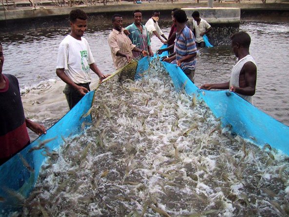
Natural reservoir of Marieta

The Marieta natural reservoir, which is located in the Shambuko Sub-zone, is one of the tourist sites of the Gash Baraka region. The reservoir is located at 600 to 700 meters from the semi-urban town of Shambuqo along the Grme-Elala road. In summer the fish population in the reservoir increases and the local people use this rare fish resource in the region, especially from October to January. The people say that the fish species that in the reservoir are big in size. In winter a vast amount of the reservoir’s water evaporates and is filled with grass for the rest of the year till summer comes.

The main water sources of the reservoir are runoffs from the Mount of Gosoma and the Mereb River. When Mereb River overflows it fills the Marieta natural water reservoir. There are tropical crocodiles, brood-stock, wild-pigs, canyon chicken and fish, as well as various bird species in the area.

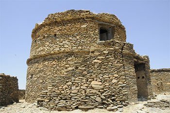
Italian Fortress in Agordat

Constructed in the early 1930s, the fortress is located about one km to the southwest of the city of Agordat. The main purpose of constructing this defensive line was to deter a potential invasion of the British colonial army from the Sudan. During this period, the commander of the fortress was Emmanuel XII and he was administering the area in cooperation with the local administrator, Deglel Jelani, who was also in charge of the town of Agordat.

The fortress has residential houses, prison buildings, water tanks, command posts and guarding stations. There is also a round building constructed using cement, but no one knows what it was used for. It was so well built that the English army was not able to go through this fortress during the World War II in their advance towards Eritrea. They had to first crush the Italian defense line in Tinqulhas. There is also an Italian fortress near Barentu with no less historical significance than that of Agordat.

Mount Adal

Mount Adal, where Hamid Idris Awate and his comrades shot the first bullets that marked the beginning of the independence struggle, is one of the most famous historical places in modern Eritrean history.

This is found 50 km to the north of Gogne. Mount Adal, surrounded by a series of mountains, is a strategic and convenient place for military confrontations.

Elephant Corridor


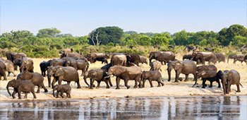
Located on the border between Eritrea and Ethiopia, the Setit River is expected to be an attractive location for local and foreign tourists in the future due to its year-round water flow and its rich wildlife and forest resources. There is an elephant enclosure area that stretches from Laelay Gash to Gogne and Haikota which covers an area of around 44,000 hectares of land. According to the survey conducted by the Ministry of Agriculture’s Wild Life Authority, the number of elephants has increased form just around 16 in 1996 to 250 today. This is considered an honorable development for the Wild Life Authority’s efforts to protect wild animals and create a climate of breeding.

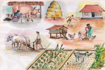
In addition to the large agro-industrial efforts that are underway, Gash-Barka is a beautiful place for people who love to travel and experience different cultures, historical sites and development projects.

Compiled by Habtom Tesfamichael

Follower
Member
Posts: 2303
Joined: 16 Feb 2013, 01:19

Re: India in Eritrea.

Post by Follower » 18 Oct 2019, 13:33

Thanks zmeselo for the infos.

Post Reply